 Gobekli Tepe Turkey Tours
Mount Nemrut: The Tomb Sanctuary at 2,150 Metres
Mount Nemrut, or Nemrut Dağı, is a 2,150 metre mountain in Adıyaman Province where King Antiochus I of Commagene built a tomb sanctuary around 62 BC. Giant stone heads and seated statues stand on two terraces beside a 49 metre burial mound. UNESCO inscribed the site in 1987. This guide covers the summit itself, the season and the road closure, the walk from the car park, the monuments on the way up, and the Göbekli Tepe tours that pair the two sites in one trip. All tour prices are the catalog prices on the comparison pages. Figures from published sources are attributed as they appear.
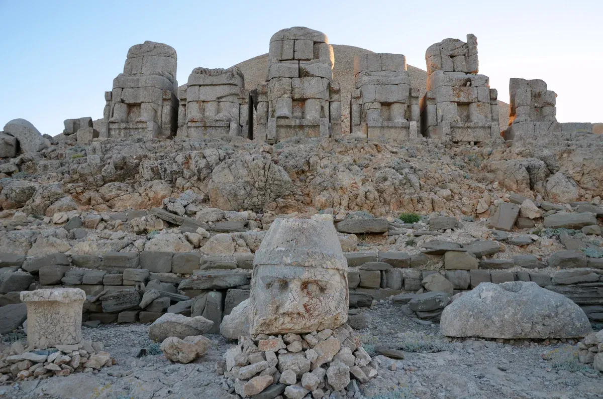
The east terrace of Mount Nemrut. Photo: Carole Raddato, CC BY-SA 2.0, via Wikimedia Commons
Quick answer Mount Nemrut in brief
Mount Nemrut is a mountain of about 2,150 m in Adıyaman Province, southeastern Turkey, topped by the 1st century BC tomb sanctuary of King Antiochus I of Commagene. Stone heads and seated statues up to 8-9 m stand on east and west terraces around a 49 m burial mound. Most visitors come between April and October, arriving near sunrise or sunset. The site is about 85 km from Adıyaman and about 180 km from Şanlıurfa by road.
Key takeaways
- Compare the multi-day tours that add Mount Nemrut to Göbekli Tepe, from a 2-day small group trip to an 8-day eastern Turkey route.
- The shortest pairing is Göbekli Tepe and Mount Nemrut 2 Days at $1,087 with the Istanbul flights and a hotel night in the price.
- See the best months, the snow risk and the walk from the car park in When You Can Go Up.
- For the Neolithic side of the region, read the Göbekli Tepe guide.
The Tomb on the Summit
A king of a small kingdom built himself a sanctuary meant to outlast empires, and it did.
Antiochus I and Commagene
Commagene was a small kingdom squeezed between Rome and Parthia in the 1st century BC. Its king Antiochus I, whose reign the UNESCO entry gives as 69 to 34 BC, built the tomb sanctuary on the summit in 62 BC. He blended Greek and Persian gods with his own image and lined the terraces with seated figures of himself among them.
Excavations began when Karl Sester, a German engineer assessing transport routes for the Ottomans, worked at the site in 1881. Theresa Goell began her campaigns in 1954. One thing a century and a half of digging has not revealed is Antiochus's tomb itself.
The burial chamber is believed to lie under the mound, but no excavation has found it.
The Tumulus and the Terraces
The centerpiece is a conical tumulus of chipped stones, 49 m high and 152 m in diameter. It is out of bounds to visitors. Cut into the natural rock on either side are two flat terraces.
The statues there are roughly 8 to 9 m tall, though Flypgs' guide describes seated torsos of about 10 m, and they depict Antiochus himself, two lions, two eagles and various gods. A walled passageway once linked the eastern and western terraces. The western terrace carries a lion slab showing Jupiter, Mercury and Mars.
The heads were removed from the statues at an unknown time and are now scattered across the site, some placed upright and each about the height of a man. Nose damage suggests deliberate iconoclasm, and the statues have not been restored. UNESCO inscribed the site in 1987 as reference 448 under criteria i, iii and iv, with a protected area of 11 ha.
- Summit height: about 2,150 m (Wikipedia's lead and Flypgs). Wikipedia's own infobox gives 2,134 m and a 2026 Medyascope report gives 2,206 m, so sources disagree on the height.
- Statues: roughly 8-9 m tall per Wikipedia.
- Tumulus: 49 m high, 152 m across, closed to walking.
- UNESCO: inscribed 1987, 11 ha, criteria i, iii and iv.
Heights and Why the Numbers Move
Even the mountain's height is a small argument. The figure most guides print is about 2,150 m. Wikipedia's infobox says 2,134 m, and Medyascope's 2026 season report gives 2,206 m.
Mediterranean Traveller adds another wrinkle: it says Antiochus raised the platform by a further 200 ft with the burial mound and that about 50 ft of that has since been lost. None of this changes the visit. What matters is that you are above 2,000 m on an exposed peak, which shapes the season, the cold and the walk described further down this page.
Sources: Wikipedia: Mount Nemrut, UNESCO criteria via Wikipedia, Medyascope
When You Can Go Up
Nemrut has a short season, a snow problem at both ends of it, and a wind that does not respect summer.
The Season and the Road
Tourists typically visit between April and October. Flypgs' guide says the roads are usually open March to November, with May and June the best months, sunrise best watched from the east terrace and sunset from the west. No source behind this page gives fixed closure dates, so treat any exact opening day you read elsewhere with care.
What is documented is how the season can begin: Medyascope reported the April opening with snow 1-2 m thick on the west terrace and visitors struggling to reach the east terrace. Pack for winter conditions even when the calendar says spring.
Sunrise or Sunset
Both work. The convention from Flypgs is sunrise on the east terrace, where the statues face the coming light, and sunset on the west terrace. Somewhere Wonderful adds a practical note that changes old advice: the site now keeps normal opening hours, so a dawn visit is no longer required.
That matters if you are driving up from Kahta or Karadut rather than sleeping at the summit. The sunset option lets you visit the roadside monuments on the way up in daylight and reach the west terrace as the light turns.
The Cold and the Walk
It is cold and windy at the top even in summer, per Mediterranean Traveller. You are standing on exposed rock above 2,000 m. Bring layers for any visit in any month.
From the car park, the walk is roughly 20 to 30 minutes: Mediterranean Traveller puts the west terrace at a 20-minute walk from the car park, Somewhere Wonderful describes a much-improved path from the ticket gate that reaches the site in 20 minutes, and Lonely Planet's entry describes about 600 m of uphill walking to either terrace. Beyond Wild Places splits it as about 15 minutes from the entrance to the east terrace and then about 5 minutes to the west. The path is uphill throughout, so allow for the altitude as well as the gradient.
Getting There: Kahta, Karadut and Distances
There is no public transport to the mountain itself, according to Beyond Wild Places. The base towns are Kahta and the smaller village of Karadut. Karadut is the closest point reachable by public transport, and Kahta to the site takes about one hour by car, and Kahta sits about 40 minutes by road from Adıyaman airport.
Distances to Nemrut per Mediterranean Traveller are 85 km from Adıyaman (Flypgs says 80 km), 100 km from Malatya, 180 km from Şanlıurfa and 240 km from Gaziantep. Most visitors rent a car, take a taxi or join a tour. Lodging names published in guides for Karadut include Nemrut Cesme Pension, Nemrut Kervansaray Hotel, Karadut Pension Nemrut and Hotel Euphrat Nemrut.
Sources: Flypgs, Medyascope, Mediterranean Traveller, Beyond Wild Places
Adventure on Mount Nemrut: Sunrise Above the Gods
A sunrise climb to the statues on the summit. Third-party video by Janet&Fatih. This site did not shoot it and has no relationship with the creator.
On the Road to the Summit
Three Commagene monuments sit on the valley route below the mountain, and the summit itself is the fourth subject. The 2-day and 3-day catalog tours stop at them.
Karakuş Tumulus
12 km from KâhtaMithridates II of Commagene built this burial tumulus around 30-20 BC for three royal women: Queen Isias, Princess Antiochis and Aka I. Doric columns about 9 m tall ring it, and the name, meaning black bird, comes from a column topped by an eagle. It is a standard stop on the Göbekli Tepe and Mount Nemrut 2 Days route.
Cendere Bridge
Reported free to visitThe Severan Bridge dates to around 200 CE and spans 120 m on a single 34.2 m arch, the longest known extant Roman arch bridge. Four Corinthian columns of 9-10 m mark it, though the column for Geta was removed after his assassination. Restored in 1997 and closed to vehicles, it stands about 55 km northeast of Adıyaman with a new road bridge 500 m east.
Arsameia
Daylight, dry weatherAt Arsameia on the Nymphaios, Antiochus I built the hierothesion, a tomb sanctuary, for his father Mithridates I Kallinikos, and an inscription in five columns describes the rites. The best-preserved dexiosis relief shows a king shaking hands with Herakles, and a carved walkway climbs the rock for 158 m.
East Terrace
SunriseThe east terrace holds the seated statue row and the scattered heads facing the dawn, with the 49 m tumulus directly behind. Reaching it takes about 15 minutes from the entrance on foot, and the light at sunrise is the classic shot. The Göbekli Tepe and Mount Nemrut 3 Days includes the mountain with entry fees in the price.
Mount Nemrut With Göbekli Tepe
Nemrut lies about 180 km by road from Şanlıurfa, the city beside Göbekli Tepe, and pairing the two sites is the most common reason international visitors come to either.
Why the Pair Works
Şanlıurfa is the natural hinge between the two sites. Göbekli Tepe lies about 15 km from the city center, and Nemrut is roughly 180 km away by road per Mediterranean Traveller. A Şanlıurfa-based trip that adds the mountain passes Karakuş Tumulus, the Cendere Bridge and Arsameia on the way, which is the route the 2-day and 3-day catalog tours below follow.
The shortest option is a 2-day small group tour from Istanbul at $1,087 that flies into Adıyaman, drives the monument road, then crosses to Şanlıurfa for Göbekli Tepe. Longer tours add Karahan Tepe and Harran, and the 8-day route adds Mardin. Read what each package includes before you compare prices, because flights and hotel nights differ sharply between them.
The Catalog Tours
The table compares the bookable tours in the catalog that visit Mount Nemrut, using the US dollar prices on their listing cards. The 2-day tour includes the round-trip domestic flights from Istanbul and one hotel night, with dinner on both nights left to you. The 3-day private tour starts and ends in Şanlıurfa and includes no flights, with two nights in restored stone mansion hotels.
The Cappadocia tour starts and ends in Cappadocia, also with no flights, and its listing names only breakfast and lunch as included, so confirm the hotel nights and admissions with the operator. The 8-day tour is an eastern Anatolia route from Gaziantep where flights and site entries apply only to the all-included option.
| Tour | Price | Days | Starts in |
|---|---|---|---|
| Göbekli Tepe and Mount Nemrut 2 Days | $1,087 | 2 days | Istanbul, flights included |
| Göbekli Tepe and Mount Nemrut 3 Days | $1,800 | 3 days, 2 nights | Şanlıurfa, no flights |
| Göbekli Tepe and Nemrut from Cappadocia | $863.65 | 3 days, 2 nights | Cappadocia, no flights |
| Eastern Turkey 8-Day Tour | $1,259 | 8 days | Gaziantep, flights in the all-included option only |
Practical Tips
Five things worth doing and four to avoid, each with the reason behind it.
Do
- Do pack warm layers even in July, because it is cold and windy at the top in summer as Mediterranean Traveller notes, and the summit sits above 2,000 m.
- Do plan on a 20 to 30 minute uphill walk from the car park to the terraces, because the sources that time it give 20 to 30 minutes, and Lonely Planet describes about 600 m of uphill path.
- Do visit the east terrace for sunrise and the west terrace for sunset if you can, because that is the split Flypgs recommends and the lion slab with Jupiter, Mercury and Mars sits on the west side.
- Do base yourself in Karadut or Kahta for an independent visit, because Karadut is the closest point reachable by public transport and Kahta is about one hour from the site by car.
- Do combine Nemrut with Göbekli Tepe if you have come this far, because Şanlıurfa is the usual base for Göbekli Tepe, Nemrut is about 180 km from it, and a tour such as Göbekli Tepe and Mount Nemrut 2 Days at $1,087 covers the flights, entries and a hotel night.
Don't
- Don't count on public transport to the mountain, because Beyond Wild Places reports that none reaches the site.
- Don't attempt the summit in late autumn through early spring without checking conditions, because Medyascope found snow 1-2 m thick on the west terrace when the 2026 season opened.
- Don't climb the tumulus, because Somewhere Wonderful reports the mound of chipped stones is out of bounds and the burial chamber beneath it has never been found.
- Don't assume every price on a long tour card includes everything, because the Cappadocia tour's inclusions list only breakfast and lunch and the 8-day tour's flights and entries apply only to the all-included option.
Mount Nemrut: Questions and Answers
Where is Mount Nemrut?
Mount Nemrut is in Adıyaman Province in southeastern Turkey, about 85 km from the city of Adıyaman and roughly 180 km from Şanlıurfa by road per Mediterranean Traveller. The guide to Şanlıurfa covers the city most visitors use as a base for the region.
How long does it take to climb Mount Nemrut?
From the summit car park, expect roughly 20 to 30 minutes of uphill walking to the terraces. Lonely Planet describes about 600 m of uphill path, and Mediterranean Traveller times the west terrace at a 20-minute walk. Driving up from Kahta takes about one hour. The route most tours take is laid out in the two-day tour comparison.
When is Mount Nemrut open?
Most visitors come between April and October, and Flypgs says the roads are usually open March to November, with May and June the best months. No official source gives fixed closure dates, and the site now keeps normal opening hours so dawn visits are not required, per Somewhere Wonderful. Snow can linger into the season opening, as Medyascope documented with 1-2 m on the west terrace at the April opening.
How much does the Mount Nemrut entrance ticket cost?
A current foreign-visitor ticket price for Mount Nemrut is not confirmed in the sources behind this page, and the 2021 figure of 20 TL is outdated. Check muze.gov.tr before travel. If you join a tour, entry is usually covered: Göbekli Tepe and Mount Nemrut 2 Days at $1,087 lists the national park, Karakuş, Arsameia and the mountain entries as included.
Can you visit Göbekli Tepe and Mount Nemrut in one trip?
Yes, and it is the standard pairing. Nemrut is about 180 km by road from Şanlıurfa, the base for Göbekli Tepe, and catalogs run everything from a 2-day small group trip to an 8-day eastern Turkey route. A good starting point is Göbekli Tepe and Mount Nemrut 3 Days at $1,800, which also covers Karahan Tepe, Harran and Arsameia. The Göbekli Tepe guide explains the site itself.
Who built the statues on Mount Nemrut?
Antiochus I of Commagene built the tomb sanctuary in 62 BC during a reign the UNESCO entry gives as 69 to 34 BC. The seated figures, roughly 8-9 m tall, show the king alongside gods, two lions and two eagles, and excavation of the tomb itself has never found his burial chamber. The historical context of the wider region is covered in the Göbekli Tepe history guide.